search
Geological map of Spain
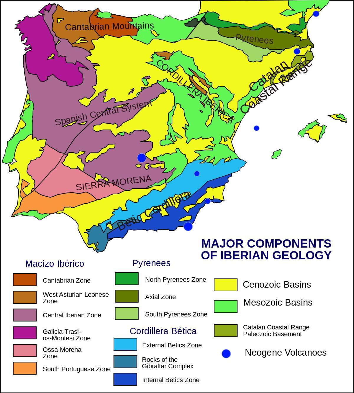
Map of Spain geological. Geological map of Spain (Southern Europe - Europe) to print. Geological map of Spain (Southern Europe - Europe) to download. The Iberian topography is characterised by a high average elevation, together with the presence of highly elevated at surfaces developed all over the Iberian peninsula (the so-called Iberian Meseta) as its shown in the geological map of Spain. These features define a landscape completely different from that of western and Mediterranean Europe and more similar to elevated areas of northern Africa and western Asia ( Birot, 1959; Gladfelter, 1971; Solé Sabarís, 1978, 1983 ). High plains in Iberia can be classified according to their geological nature: planation surfaces developed mainly on Palaeozoic and Mesozoic rocks and sedimentation surfaces of Neogene rocks.
From the geological point of view, two main types of high plains can be distinguished in the Iberian peninsula: high plains coinciding with Tertiary sedimentary basins, with highest preserved deposits Late Miocene to Pliocene in age and subhorizontal bedding. The main representatives of this kind of surfaces (many of them erosional in their present form) are in the Duero Basin (including the Almazan Basin), at elevations between 700 and 1200 m a.s.l., and in the Eastern Tagus Basin, at elevations between 500 and 1000 m a.s.l as its mentioned in the geological map of Spain. High plains consisting of eroded segments of Mesozoic and Palaeozoic rocks with planation surfaces (pediplains), developed on the mountain ranges (fold-and-thrust systems and basement uplifts) formed during the Paleogene–Early Miocene.
The relationship between topographic elevation and crustal thickness or Bouguer anomaly allows for the different geological areas to be differentiated according to their geophysical signature. In the Iberian peninsula, elevated zones within the northern part of the plate coincide with areas of maximum crustal thickness and a decrease (more negative) in the Bouguer anomaly, especially in the Cantabrian mountains, the Pyrenees (western zone) and the Central System as you can see in the geological map of Spain, where no important extensional movements took place during Mesozoic times. In the three main mountain ranges (Pyrenees, Betics and Central System) there is a rough exponential relationship between both parameters, the Central System showing higher elevations for similar crustal thicknesses than the Betics (intermediate relationship) and the Pyrenees (minimum elevation/ thickness ratio).


